- Dartmouth Park Hill
- St. Joseph’s Church, Highgate
- Hampstead Heath
- Kenwood House
- The Old Bull and Bush
- Whitestone Pond
- Alexandra and Ainsworth Estate
- Primrose Hill
- ZSL London Zoo
- Regent’s Park
- Post Office Tower
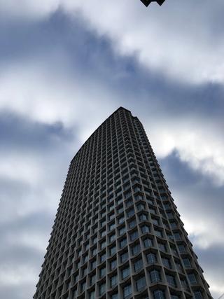
- Centre Point
- Lincoln’s Inn Fields
- Holborn Bars
- Mount Pleasant Sorting Office
Another clockwise route, as this direction is more familiar to me and it trades shorter, punchier climbing for more languid, prolonged descending, which is surely more fun. The Camden boundary is a tour of contrasts, taking in some of London’s finest park land, fanciest mansions and densest housing, contemporary architecture and hallowed inns of court, stretching from the outer reaches of Cricklewood and Kilburn (and the highest point in central London) to within a stone’s throw of the river.
The starting point sets us off at the top of York Way on the shared boundary with Islington, from which we almost immediately deviate in order to negotiate a one-way system. Camden Park Road leads us to the crossing with Camden Road and past one of a great many churches that crop up on this route – though this one has been deconsecrated and converted into upmarket residential units as “Church Studios”. Its spire now hosts several communications antennae to reinforce the idea of that change of purpose.
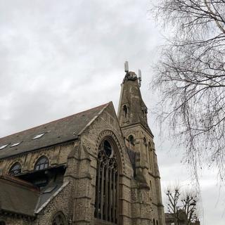
We cross on to Torriano Avenue which we follow past a couple of quite characterful estate buildings, crossing Leighton Road on to a short climb past the interestingly-named (and very minor) Charlton King’s Road on the right. At the top, we turn left on to Brecknock Road and head towards Tufnell Park tube station. On a clear day there are some nice views ahead and to the right as we descend, including of the green dome of St Joseph’s Church, Highgate, which we'll meet up-close shortly.
Summer 2022 update: The section of Dartmouth Park above Magdala Avenue is currently southbound-only for about 50m due to construction work. You may need to take to the pavement or walk, FYI. It's a temporary setup but may be in place for a while judging by the scale of works being undertaken.
Crossing the junction at Tufnell Park tube, we’re on to the bottom of the major climb of the route – Dartmouth Park Hill. This comes in two sections, with a flat stretch and slight downhill between them. Dartmouth Park itself runs alongside the flat section, but there’s not much of a view from the road as all you can see is a huge Victorian covered reservoir. As the road descends again, there’s a notable coffee stop in the form of Crick’s Corner on the right, before we return to the climb, passing the substantial estate of Whittington Hospital and its old accommodation blocks. This second pitch of Dartmouth Park Hill is definitely more challenging, but affords a great view of the heights of St Joseph’s. A bike with gears is definitely an advantage here, but it’s do-able on a single-speed. As the road swings left, then disappears right: that’s the top. It looks worse than it is.
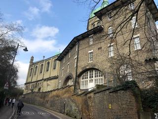
At these traffic lights, we’re at the corner of Camden to the west, Islington to the east, and Haringey to the north. Turning uphill on to the High Street, we proceed through the picturesque shops of Highgate (past the Ghanaian High Commission on the right) and turn left at the second of two mini-roundabouts on to Hampstead Lane. As an aside, we’re close to the top of Swain’s Lane here, the steepest road in London and one much beloved of London cyclists. It cleaves through the middle of Highgate Cemetery, and is well worth a visit in its own right.
As we descend Hampstead Lane, there’s plenty to look at – the tower and chimneys of Athlone House come up on the left beyond the wall and gates – this Victorian mansion was home to an RAF intelligence school during the Second World War. It is followed by entrances to another stately home, Kenwood House, on the left, and the expansive playing fields of Highgate School on the right. We follow the rise of the road for a short distance before taking a detour – the borough boundary passes through Sandy Heath up ahead, but on bikes we aren’t allowed to follow it. The diversion is worth it, though. The descent of Winningdon Road and Ingram Avenue takes us past a number of startlingly large modern houses, back to the edge of the Heath at Wildwood Road, before we start climbing again. As the road becomes Hampstead Way we pass a number of attractive brick-built houses – these slightly more modest – including one with distinctive white window-frames and shutters. Just after this one is a fairly defensive-looking low building behind a fence, with some white-on-blue signage that has a slight aura of TfL about it. This is an emergency exit from the Northern Line, and sits on the site of the once-planned North End tube station, also known as Bull and Bush. Some platform excavation was conducted in the early 1900s, but the cancellation of a planned residential development nearby obviated the need for a station here and it was never completed. And indeed as we continue and turn left on to North End Road, we are greeted by the Old Bull and Bush pub which lent the planned station its alternative name.
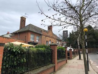
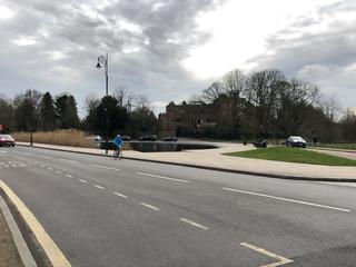
Following North End Way to the top, we cross over a mini-roundabout by Jack Straw’s Castle, a Grade II listed former pub, and find ourselves at Whitestone Pond. Here, we’re pretty much at the highest point in central London (the actual point is slightly to the north on Spaniard’s Road) and there are some great views to be had off to the west. Having accrued a bit of height, it’s now time to spend it. Across the pond on to West Heath Road, we start a meandering descent past more mega-mansions, freewheeling for a decent distance before taking the fork at Pattison Road and arriving at a T-junction with Finchley Road. Turning left, there’s a slightly hectic junction to be negotiated here on to Hendon Way – we have to join traffic coming from the opposite direction, so take it carefully. No harm in hopping off here and walking it – in any case, we immediately turn left on to Lyndale Avenue, and leave the A41 behind.
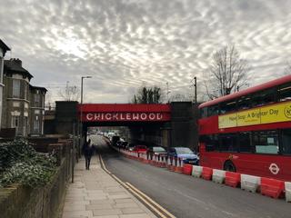
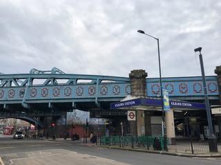
A couple of turns on these quiet residential streets brings us to the grounds of University College School (all three for the price of one) and we’ll take the footpath to pass through their playing fields on to Menelik Road. The Camden border is just ahead of us along some railway tracks, so we need to take another brief detour to get back to it. Turning on to Westbere Road, we find ourselves at a crossroads next to the bright red bridge of Cricklewood Station, which we will pass beneath. We then thread through a couple of back streets to find ourselves on Cricklewood Broadway – the A5. We’ll follow this for a couple of miles – it’s fairly steady going and while there’s often heavy traffic, it’s usually slow-moving. There’s a striking tower block – Windmill Court – to the right as we descend towards Kilburn Station which has its own highly decorated bridge, immediately followed by two more bridges, albeit of slightly more austere design. On we go, past Kilburn High Road Overground station, until we eventually depart the A5 on to Greville Place.
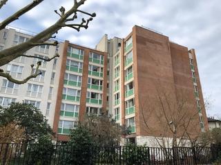
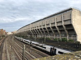
There’s some fine housing stock to be seen here including the green-and-tan of Vivian Court on the left and the white balconies of Greville Hall on the right. At the top we meet Abbey Road (yes, that one), and while the borough boundary carries straight on, there’s something just off-route here that’s well worth seeing. Take a left and towards the crossroads and traffic lights ahead, then look to your right as you pass over the railway bridge. This is the Brutalist magnificence of the Grade II listed Alexandra and Ainsworth Estate, with its “ziggurat” rear profile lofted out over the railway lines. From the front, its terracing evokes the Barbican or the Brunswick Centre, and I find it completely fascinating.
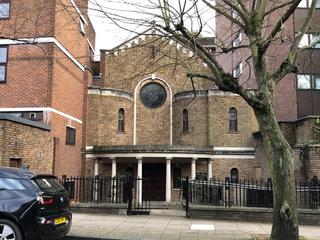
Back to the plan, we follow Boundary Road as it sweeps up towards Finchley Road, crossing over and zig-zagging through the back-streets. At the end of Norfolk Road, where we join Avenue Road, there are a pair of borough street signs showing the boundary – Westminster to the right, and Camden to the left. We’re rolling downhill now, but there are a few more side-streets to explore as we try to stick to the boundary line. Turning left into St Edmund’s Terrace, don’t miss the Handmaids of the Sacred Heart of Jesus, a tiny church nestled between two residential blocks on the right. At the top of the terrace is Primrose Hill, a charming park and commanding viewpoint if you hop off here and walk to the top.
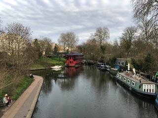
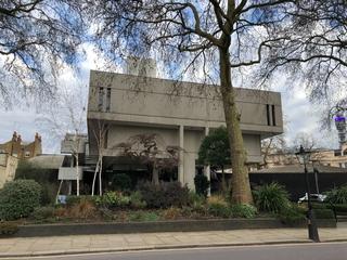
Continuing downhill we reach Prince Albert Road, which forms the top of the outer boundary of Regent’s Park. Passing the aviaries of ZSL London Zoo, we turn right on to the footbridge over Regent’s Canal and on to the Outer Circle. From the footbridge you can see the Feng Shang Princess, a long-established floating Chinese restaurant (and section of towpath featured in The Gentlemen). The Camden boundary cuts through Regent’s Park so we’ll follow the Outer Circle to its south-east corner, passing The Danish Church, London and the grand residences of Cumberland Terrace and Chester Terrace on the left. Towards the corner, you can see the impressive modern shape of the Royal College of Physicians.
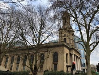
At the park gates we turn left and then left again on to Albany Street, before immediately turning to the right and circling back to face Euston Road and Great Portland Street station. In the process we ride around the former Holy Trinity Church, Marylebone, a Grade I listed former Anglican church designed by Sir John Soane. Its storied history includes use as a book warehouse by Penguin, and it’s now a “wedding department store” and events space.
We cross Euston Road and take the first slight left on to Bolsover Street, then immediately turn left on to Greenwell Street and right on to Cleveland Street. This marks the boundary between Camden and Westminster, but as only part of the street permits southbound travel we have to do a bit of a wiggle to approximate it. As we head down Cleveland Street, we get a good look at the approaching Post Office Tower, and away to our left (on the other side of the buildings) is Fitzroy Square Garden. We’ll round the corner on to Maple Street then take a right on to Charlotte Street. This we follow all the way down, over several junctions, until it becomes Rathbone Place. There are a great many interesting buildings and eateries along the way, including the Fitzroy Tavern on the left and the Charlotte Street Hotel on the right.
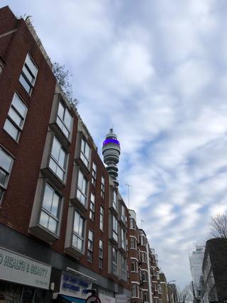
As we join Rathbone Place we’ll take a left on to Gresse Street, turn the corner, then take another left on to Stephen Street. This takes us underneath the 1+2 Stephen Street building, home to several film, media and production companies including BFI, and on to Tottenham Court Road. A right turn here and we’ll follow it down to the junction with Oxford Street, where we get a great view of Centre Point and the redeveloped Tottenham Court Road station. Crossing Oxford Street, we continue into Theatreland, with the famous music shops of Denmark Street – or what remains of them – on the left, and eventually reach Cambridge Circus.
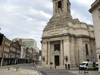
Crossing over to continue on Charing Cross Road, we make a few more twisting turns to try to reconcile the boundary line with the local one-way streets. A left turn on to Litchfield Street, a right on to Upper St Martin’s Lane, then a left on to Long Acre as we enter the Covent Garden district. We take a left on Mercer Street and follow it up to Seven Dials – the original Monmouth Coffee and Neals Yard shops are just to the north, and the Seven Dials Market just to the east here offers plenty of food options. We’ll head off to the north-east along Short’s Gardens, before taking a right turn on to Endell Street, a left on to Shelton Street, then a left to rejoin Long Acre. Across the junction ahead of us is Freemasons’ Hall, the massive Art Deco headquarters of the United Grand Lodge of England, built in 1933. Somewhat tangentially, on the opposite expanse of pavement you can find several examples of the “Camden bench”, a cast concrete piece of street furniture designed to deter rough sleeping and anti-social behaviour, and an infamous example of “hostile architecture”.
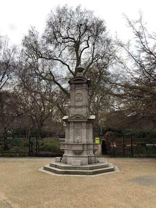
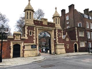
We turn to the south of the Hall along Wild Street, which offers a glimpse into the Peabody Trust estate on the right-hand side and the somewhat imposing One Kemble Street building on the left. We join Kemble Street and follow it on Kingsway – we’re intending to cross over to Sardinia Street, but the central barrier makes this a challenge so turning left to use the Pelican crossing a short way up the road is highly recommended. As you turn into Sardinia Street, don’t miss the sculpture on the southwest corner of the LSE building here. This is Lincoln’s Inn Fields, ringed by many a fine building home to legal chambers and LSE facilities, among others, and steeped in history. The Camden border runs along the southern edge of the square, but the one-way system requires us to go around, giving a chance to spot Sir John Soane’s Museum (architect of Holy Trinity Church, Marylebone, which made an appearance earlier) at no. 13 on the northern side. There's more sculpture in the north-east corner; towards the south-east corner we find the grand entrance to Lincoln’s Inn, and opposite it a fountain known as the Twells memorial. Lincoln’s Inn is only open during weekdays, and is currently closed to the public altogether due to COVID–19, but if you’re passing and have the opportunity to go inside, don’t miss it – it’s a corner of London unlike any other.
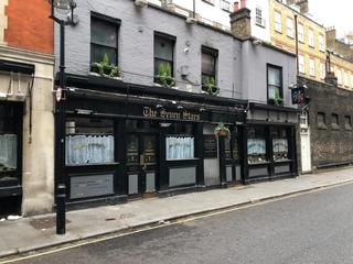
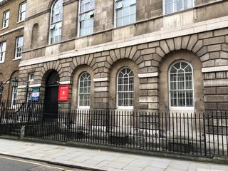
Following Serle Street out of the square and taking a left turn on to Carey Street, we pass The Wig Box, in case you’d forgotten we’re in the heart of the old legal district, and The Seven Stars, a splendid place to enjoy a lunchtime sharpener after a taxing morning in chambers. On the right is the back of the Royal Courts of Justice, well worth a view from the front on the Strand/Fleet Street. For now however we’ll take a turn on to Chancery Lane and follow it all the way up, passing many more curiosities. Towards the top, check out the frontage of 10 Stone Buildings, home to the Inns of Court Yeomanry and signed for the Army Reserve Centre, which still sports visible bomb damage on its facade from a German aerial raid in WWI.
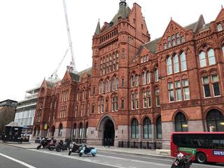
At the top of Chancery Lane we turn right on to High Holborn, and cross over the junction by Chancery Lane underground station. Pull in to one of the cycle parking spaces in the median to take in the spectacle of Holborn Bars on the left, AKA the Prudential Assurance Building, which until recently was completely concealed by scaffolding, but as of this writing is now revealed once more. We continue to Holborn Circus and take a slight left on to Charterhouse Street. At the crossroads at the bottom, we stand at the corner between Camden, Islington and the City. This area is under heavy redevelopment, involving parts of the old Smithfield Market and the expansion of Farringdon Station, so there may well be new buildings to admire by the time you visit. Turning left on to Farringdon Road, we pass the Zeppelin Building at no. 61, destroyed by an airship raid in 1915.
Reaching Clerkenwell Road, we turn left and then immediately right on to Herbal Hill, descending the narrow lane to Ray Street by the Coach and Horses pub. Turning left, we pass along Warner Street, glancing left to the bottom of Eyre Street Hill where the classic frontage of Chiappa Ltd Organ Builders can be seen. Warner Street passes under the ornate bridge that carries Rosebery Avenue, and beyond it we come to the crossroads with Mount Pleasant, and the Mount Pleasant Sorting Office. On Phoenix Place, we pass the entrance to Mail Rail, the underground railway formerly used to shuttle mail between Post Office facilities in central London, now a visitor attraction well worth a visit. A little further on the left, The Postal Museum is similarly recommended.
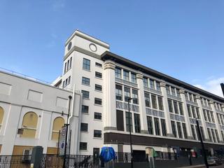
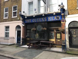
Reaching Calthorpe Street, we turn right to follow the side of Mount Pleasant and then left at the crossroads on to King’s Cross Road. This forms the border but we’ll soon run into another one-way system, so we’ll do our best to approximate. Following the road, we’re funnelled on to Acton Street, which we climb to the top, passing The Queen’s Head, held by some to be the best pub in London. Reaching Gray’s Inn Road, we turn right and keep left, then as the brick superstructure of King’s Cross Station comes into view, take the cycle path on to the pavement and the signalled crossing over the junction on to York Way.
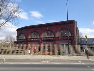
York Way takes us alongside the station complex, but high walls prevent us getting much of a view. As York Way starts to climb, we pass King’s Place on the right, home of The Guardian and Observer. There’s an opportunity to dive off the route here to the nearby Granary Square, which offers a variety of food and drink options and good spot for a rest stop. Carrying on up York Way, at the crest of the first hill we pass the remains of York Road underground station on what’s now the Piccadilly Line, closed in 1932 having never seen much passenger traffic. The road drops away now but soon we’re climbing again, passing under two rail bridge decks, and as we cross the junction with Agar Grove and Brewery Road, we’re back at the Market Estate where we began.
Published: 6th March 2021
Updated: 16th October 2022
